普吉特海湾

 Clash Royale CLAN TAG#URR8PPP
| 普吉特海湾 Puget Sound | |
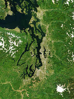 普吉特海湾卫星图像 | |
名称来源于:彼得·普吉特 | |
| 国家 | |
|---|---|
| 省/州/邦 | 华盛顿州 |
| 地区 | 普吉特海湾低地 |
| 城市 | 西雅图、塔科马、奥林匹亚、埃弗里特、布雷默顿 |
| 河流 | Deschutes River、Nisqually River、皮阿拉普河、Duwamish River、Cedar River、Snohomish River、Stillaguamish River、Skagit River、Skokomish River |
| 坐标 | 47°49′59″N 122°26′04″W / 47.83315°N 122.43458°W / 47.83315; -122.43458 |
| 长度 | 100 mi(161 km)[1] |
| 宽度 | 10 mi(16 km) |
| 深度 | 205 ft(62 m)[1] |
| 容积 | [1] |
| 流域面积 | 12,138 mi²(31,437 km²)[2] |
| 面积 | 1,020 mi²(2,642 km²)[1] |
| 流量 | |
| - 平均流量 | 41,000 ft³/s(1,161 m³/s)[1] |
| - 最大流量 | 367,000 ft³/s(10,392 m³/s) |
| - 最小流量 | 14,000 ft³/s(396 m³/s) |
普吉特海湾(英语:Puget Sound;/ˈpjuːdʒɪt/)是一個位於美国西雅圖西岸峡灣,北臨加拿大溫哥華島,屬薩利希海的一部份。海灣本身是一個河口系統[3],結構複雜,交織着通往海洋的水道和盆地。當中有一大一小的通道透過胡安·德富卡海峡与太平洋相连,較大的為阿德默勒尔蒂湾(Admiralty Inlet),較小的是迷幻水道(Deception Pass)。通過阿德默勒尔蒂湾的海水,佔海灣與胡安·德富卡海峡之間的潮汐水體交換的2%[1]。海灣的範圍,從北起迷幻水道起計算,到南方的奧林匹亞,距離約160公里,平均海深約60公尺,最深處是基沙普縣的Indianola與Kingston之間的Point Jefferson對出海底,深度有280公尺。而海灣的主要盆地位於惠德比島南端與塔科马之間,水深180公尺。[1]
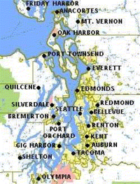
整个海湾周边地区集中了华盛顿州九大城市中的六个:西雅图、塔科马、埃弗里特、肯特、贝尔维尤和费德勒尔韦,人口约400万,通稱為普吉特地區。
目录
1 動植物
2 歷史
3 參考資料
4 延伸閱讀
5 外部連結
動植物
象拔蚌是當地潮間帶的特產,每隻的平均年齡約80歲,最高的生存了160多年[4][5]。
歷史
參考資料
^ 1.01.11.21.31.41.51.6 Lincoln, John H. The Puget Sound Model Summary. Pacific Science Center. [2009-12-23]. (原始内容存档于2015-03-10).
^ Watershed Boundary Dataset. USDA, NRCS, National Cartography and Geospatial Center. [2010-09-04]. ArcExplorer Geographic information system|GIS data viewer.
^ Basic Information about Estuaries. United States Environmental Protection Agency. [2011-03-14].
^ DAVID W JAMISON. EXPLORE PUGET SOUND HABITATS AND MARINE LIFE. [2013-09-21] (英语).|chapter=被忽略 (帮助)
^ 盤點自然界的十大「壽星」 南極海綿壽命超過了1550年 (組圖). 阿波羅新聞網. 2013-09-21 [2013-09-21] (中文(繁體)).
延伸閱讀
Jones, M.A. Geologic framework for the Puget Sound aquifer system, Washington and British Columbia (U.S. Geological Survey Professional Paper 1424). Reston, VA: U.S. Department of the Interior, U.S. Geological Survey. 1999.
LeWarne, Charles P. Utopias on Puget Sound, 1885-1915. University of Washington Press. 1995. ISBN 9780295974446.
Prosser, William Farrand. A history of the Puget Sound country : its resources, its commerce and its people : with some reference to discoveries and explorations in North America from the time of Christopher Columbus down to that of George Vancouver in 1792, when the beauty, richness and vast commercial advantages of this region were first made known to the world. Lewis Pub. Co. 1903. Available online through the Washington State Library's Classics in Washington History collection
外部連結
维基共享资源中相关的多媒体资源:普吉特海湾 |
University of Washington Libraries Digital Collections – Oliver S. Van Olinda Photographs A collection of 420 photographs depicting life on Vashon Island, Whidbey Island, Seattle, and other communities of Washington State's Puget Sound from the 1880s through the 1930s.- Pacific Science Center: Geology of Puget Sound
- USGS:Puget Sound earthquake origins
Features of Puget Sound Region: Oceanography And Physical Processes, Chapter 3 of the State of the Nearshore Report[永久失效連結], King County Department of Natural Resources, Seattle, Washington, 2001.
| |||||||||||||||||||||||||||||||||||||||||||||||

|