Lake Rotoiti (Bay of Plenty)

 Clash Royale CLAN TAG#URR8PPP
| Lake Rotoiti | |
|---|---|
 | |
| Location | Rotorua District, Bay of Plenty Region, North Island |
| Coordinates | 38°02′20″S 176°25′40″E / 38.0390°S 176.4277°E / -38.0390; 176.4277Coordinates: 38°02′20″S 176°25′40″E / 38.0390°S 176.4277°E / -38.0390; 176.4277 |
| Type | crater lake |
| Primary outflows | Kaituna River |
Basin countries | New Zealand |
| Max. length | 15 kilometres (9.3 mi)[1] |
| Max. width | 3.6 kilometres (2.2 mi)[1] |
| Surface area | 34.3 square kilometres (13.2 sq mi)<[1] |
| Average depth | 33 metres (108 ft)<[1] |
| Max. depth | 93.5 metres (307 ft)[1] |
| Surface elevation | 279 metres (915 ft)[1] |
| References | [1] |
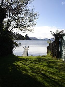
Lake Rotoiti is a lake in the Bay of Plenty region of New Zealand.[2] It is the northwesternmost in a chain of lakes formed within the Okataina caldera. The lake is close to the northern shore of its more famous neighbour, Lake Rotorua, and is connected to it via the Ohau Channel. It drains to the Kaituna River, which flows into the Bay of Plenty near Maketu.
The full name of the lake is Te Rotoiti-kite-a-Īhenga,[3] which in the Māori language means "The Small Lake Discovered By Īhenga", the Māori explorer also credited with discovering Lake Rotorua. Legend says that the lake was named as such because when Ihenga first saw it, he was only able to see a small part of it and thought the lake was a lot smaller.
Since the 1960s, the quality of lake water has been negatively affected by inflows of nitrogen rich water from Lake Rotorua, agricultural run-off from surrounding farms and seepage from domestic septic tanks.[4] The effects of this included an almost permanent algal bloom in the Okere arm of the lake and choking lake weed growth in other still areas of the lake. A barrier to divert the nutrient rich waters of Lake Rotorua into the Kaituna River was completed in late 2008. The Bay of Plenty Regional Council expected to see improvement in lake water quality within five years [5] and the Rotorua Te Arawa Lakes Program reported in 2013 that the intervention has significantly improved water quality. Water quality is the highest it has been in decades, on track to meet targets set by the Program to meet community expectations.[6]
Lake Rotoiti has thermal hot-spring baths on the southern shore which are accessible by boat.[7]
References
^ abcdefg Lowe, D.J., Green, J.D. (1987). Viner, A.B., ed. Inland waters of New Zealand. Wellington: DSIR Science Information Publishing Centre. pp. 471–474. ISBN 0-477-06799-9.CS1 maint: Multiple names: authors list (link).mw-parser-output cite.citationfont-style:inherit.mw-parser-output .citation qquotes:"""""""'""'".mw-parser-output .citation .cs1-lock-free abackground:url("//upload.wikimedia.org/wikipedia/commons/thumb/6/65/Lock-green.svg/9px-Lock-green.svg.png")no-repeat;background-position:right .1em center.mw-parser-output .citation .cs1-lock-limited a,.mw-parser-output .citation .cs1-lock-registration abackground:url("//upload.wikimedia.org/wikipedia/commons/thumb/d/d6/Lock-gray-alt-2.svg/9px-Lock-gray-alt-2.svg.png")no-repeat;background-position:right .1em center.mw-parser-output .citation .cs1-lock-subscription abackground:url("//upload.wikimedia.org/wikipedia/commons/thumb/a/aa/Lock-red-alt-2.svg/9px-Lock-red-alt-2.svg.png")no-repeat;background-position:right .1em center.mw-parser-output .cs1-subscription,.mw-parser-output .cs1-registrationcolor:#555.mw-parser-output .cs1-subscription span,.mw-parser-output .cs1-registration spanborder-bottom:1px dotted;cursor:help.mw-parser-output .cs1-ws-icon abackground:url("//upload.wikimedia.org/wikipedia/commons/thumb/4/4c/Wikisource-logo.svg/12px-Wikisource-logo.svg.png")no-repeat;background-position:right .1em center.mw-parser-output code.cs1-codecolor:inherit;background:inherit;border:inherit;padding:inherit.mw-parser-output .cs1-hidden-errordisplay:none;font-size:100%.mw-parser-output .cs1-visible-errorfont-size:100%.mw-parser-output .cs1-maintdisplay:none;color:#33aa33;margin-left:0.3em.mw-parser-output .cs1-subscription,.mw-parser-output .cs1-registration,.mw-parser-output .cs1-formatfont-size:95%.mw-parser-output .cs1-kern-left,.mw-parser-output .cs1-kern-wl-leftpadding-left:0.2em.mw-parser-output .cs1-kern-right,.mw-parser-output .cs1-kern-wl-rightpadding-right:0.2em
^ "Place name detail: Lake Rotoiti". New Zealand Gazetteer. Land Information New Zealand. Retrieved 2009-03-18.
^
McKinnon, Malcolm (2 March 2009). "Volcanic Plateau places - Lake Rotoiti to Lake Rotomā". Te Ara New Zealand. Retrieved 19 September 2012.
^ "Ohau Channel Diversion Wall Monitoring". June 2011. Retrieved 2013-01-03.
^ Ohau Channel Diversion Wall
^ "Rotorua Te Arawa Lakes Program, Lake Rotoiti Water Quality Status". Retrieved 2015-04-30.
^ "Lake Rotoiti, Lake Rotoehu and Lake Rotoma". Retrieved 2013-01-03.