Flinders Lane, Melbourne

 Clash Royale CLAN TAG#URR8PPP
Flinders Lane Victoria | |
|---|---|
 | |
Flinders Lane | |
 Flinders Lane | |
| Coordinates |
|
| General information | |
| Type | Street |
| Length | 2 km (1.2 mi) |
| Major junctions | |
| West end | Spencer Street |
William Street Market Street Queen Street Elizabeth Street Swanston Street Russell Street Exhibition Street | |
| East end | Spring Street |
| Location(s) | |
| Suburb(s) | Melbourne |
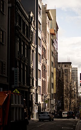
Flinders Lane is a minor street and thoroughfare in the central business district of Melbourne, Australia. The laneway runs east-west from Spring Street to Spencer Street in-between Flinders and Collins Streets. Originally laid out as part of the Hoddle Grid in 1837, the laneway was once the centre of Melbourne's rag trade and is still home to boutique designers, now perched alongside numerous hotels, loft apartments, cafes and bars.[1]
Many historic buildings are found on Flinders Lane with a history of strict height limits helping to preserve the buildings from redevelopment.[2] Despite the loss of some significant buildings over time, it is still known for its SoHo atmosphere and chic buildings.[1]
Contents
1 History
1.1 Garment Trade
1.2 Hells Angels Shootings
2 Notable buildings
3 Transport
4 See also
5 References
History

Flinders Lane between Queen and Elizabeth Streets
Garment Trade
In the 1880s, large soft-goods import warehouses established Flinders Lane as the heart of the clothing trade. This was because of the Lane’s proximity to wharves and railway stations, and centrality to Melbourne’s population.[3]
For over one hundred years ‘The Lane’ was an Australian institution due to its clothing and textiles (the schmatte trade).[4] Buyers could come from the country and ‘do’ the Lane in one session, which featured many Jewish migrant businesses. For a large part of the twentieth century the garment trade remained an important industry in Flinders Lane.[3] The number of clothing firms on the street reached 610 in 1939, and this level of activity was maintained until the early 1960s. In the 1960s and 1970s these businesses began to close due to changing requirements for space and labour, rising rents and traffic congestion.[4]
Hells Angels Shootings
On Monday 18 June 2007, a shooting incident occurred on the corner of Flinders Lane and William Street when Hells Angels member Christopher Hudson shot and killed Brendan Keilar and wounded two others.[5] Keilar was posthumously awarded the Royal Humane Society of Australasia's medal for bravery as he was shot and killed after intervening to save one of the victims.[6]
Notable buildings

The City Library building between Swanston and Elizabeth Streets.
Flinders Lane has many notable multi-storey warehouses and buildings,[7] many included on the Victorian Heritage Register or National Trust of Australia, including:
- Murray House (1880)
- Leicester House (1886) by T J Crouch
- Chapter House (1891) by William Butterfield
Ross House (1898) by Sulman & Power- Tomasetti Warehouse (1899) by H W & F B Tompkins
Milton House (1901) by Sydney Smith & Ogg- Manchester House (1911) by Bates Peebles & Smart
Majorca Building (1928) by Harry Norris
Other buildings now lost include:
- 'Australian Building' (1889) by Henry Kemp (a 12-storey Queen Anne building third tallest in the world when completed), demolished 1980
- Champions Hotel (1905) on the corner of Swanston Street, demolished 1960
Western Market (1841) on the block bounded by Market, Collins and William Street, demolished 1961
New Zealand Loan and Mercantile Agency Company Woolstore (1882) at 522 Flinders Lane, demolished 1973
Transport
There is a short section of the street between Collins and Market Streets that the route 58 tram runs down.
Though there is no other public transport running down Flinders Lane itself, the street is well connected due to the surrounding rail, tram and bus infrastructure.
See also
- List of streets and roads in Melbourne
 Australian Roads portal
References
^ ab "Flinders Lane :: Punthill Apartments". www.punthill.com.au. Retrieved 2017-01-19..mw-parser-output cite.citationfont-style:inherit.mw-parser-output .citation qquotes:"""""""'""'".mw-parser-output .citation .cs1-lock-free abackground:url("//upload.wikimedia.org/wikipedia/commons/thumb/6/65/Lock-green.svg/9px-Lock-green.svg.png")no-repeat;background-position:right .1em center.mw-parser-output .citation .cs1-lock-limited a,.mw-parser-output .citation .cs1-lock-registration abackground:url("//upload.wikimedia.org/wikipedia/commons/thumb/d/d6/Lock-gray-alt-2.svg/9px-Lock-gray-alt-2.svg.png")no-repeat;background-position:right .1em center.mw-parser-output .citation .cs1-lock-subscription abackground:url("//upload.wikimedia.org/wikipedia/commons/thumb/a/aa/Lock-red-alt-2.svg/9px-Lock-red-alt-2.svg.png")no-repeat;background-position:right .1em center.mw-parser-output .cs1-subscription,.mw-parser-output .cs1-registrationcolor:#555.mw-parser-output .cs1-subscription span,.mw-parser-output .cs1-registration spanborder-bottom:1px dotted;cursor:help.mw-parser-output .cs1-ws-icon abackground:url("//upload.wikimedia.org/wikipedia/commons/thumb/4/4c/Wikisource-logo.svg/12px-Wikisource-logo.svg.png")no-repeat;background-position:right .1em center.mw-parser-output code.cs1-codecolor:inherit;background:inherit;border:inherit;padding:inherit.mw-parser-output .cs1-hidden-errordisplay:none;font-size:100%.mw-parser-output .cs1-visible-errorfont-size:100%.mw-parser-output .cs1-maintdisplay:none;color:#33aa33;margin-left:0.3em.mw-parser-output .cs1-subscription,.mw-parser-output .cs1-registration,.mw-parser-output .cs1-formatfont-size:95%.mw-parser-output .cs1-kern-left,.mw-parser-output .cs1-kern-wl-leftpadding-left:0.2em.mw-parser-output .cs1-kern-right,.mw-parser-output .cs1-kern-wl-rightpadding-right:0.2em
^ Melbourne, School of Historical Studies, Department of History, The University of. "Skyscrapers - Entry - eMelbourne - The Encyclopedia of Melbourne Online". www.emelbourne.net.au. Retrieved 2017-01-19.
^ ab Melbourne, School of Historical Studies, Department of History, The University of. "Flinders Lane - Entry - eMelbourne - The Encyclopedia of Melbourne Online". www.emelbourne.net.au. Retrieved 2017-01-19.
^ ab "FASHION IN THE LANES". Walking Tours of Melbourne. 2012-02-02. Retrieved 2017-01-19.
^ Karen Kissane and Kate Hagan, 13 May 2008. "Gunman was 'out of his mind, insane': victim", The Age. Retrieved on 25 July 2009
^ Cooper, Mex. "Son of slain solicitor accepts bravery award". The Sydney Morning Herald. Retrieved 2017-01-19.
^ Fishlock, Sean. "Melbourne Buildings [Walking Melbourne - Heritage, Architecture, Skyscraper and Buildings]". www.walkingmelbourne.com. Retrieved 2017-01-19.