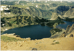
Beartooth Mountains

 Clash Royale CLAN TAG#URR8PPP
 | Beartooth Mountains | |
|---|---|
 | |
| Highest point | |
| Peak | Granite Peak |
| Elevation | 12,807 ft (3,904 m) |
| Coordinates | 45°09′48″N 109°48′26″W / 45.16333°N 109.80722°W / 45.16333; -109.80722Coordinates: 45°09′48″N 109°48′26″W / 45.16333°N 109.80722°W / 45.16333; -109.80722 |
| Geography | |
 Beartooth Mountains Location in Montana Show map of Montana  Beartooth Mountains Location in the United States Show map of the US | |
| Country | United States |
| States | Montana and Wyoming |
| Parent range | Rocky Mountains |
| Geology | |
| Orogeny | Laramide |
The Beartooth Mountains are located in south central Montana and northwest Wyoming, U.S. and are part of the 944,000 acres (382,000 ha) Absaroka-Beartooth Wilderness, within Custer, Gallatin and Shoshone National Forests. The Beartooths are the location of Granite Peak, which at 12,807 feet (3,904 m) is the highest point in the state of Montana. The mountains are just northeast of Yellowstone National Park[1] and are part of the Greater Yellowstone Ecosystem. The mountains are traversed by road via the Beartooth Highway (U.S. 212) with the highest elevation at Beartooth Pass 10,947 ft (3,337 m)). The name of the mountain range is attributed to a rugged peak found in the range, Beartooth Peak, that has the appearance of a bear's tooth.

The Bears Tooth in the Beartooth Mountains
The Beartooth Mountains sit upon the larger Beartooth Plateau, the largest true high elevation plateau in the United States.
Contents
1 History and ecology
2 Geology
3 Elevation and peaks
4 See also
5 References
6 External links
History and ecology
The remoteness of the region contributed to its obscurity until the 1870s. The Crow tribe of Native Americans used the valleys of the mountains for hunting game animals and for winter shelter from the harsh winds of the plains. Though trappers entered the region in the 1830s, formal exploration by the U.S. Government did not occur until 1878. Since then, almost 400 species of plants have been discovered and the Beartooths are considered to be the most biologically unique mountain range in North America. The region is also home to one of the largest populations of grizzly bears outside of Alaska and Canada. Black bears, mountain goats, bighorn sheep, elk, moose, wolverine, mountain lion, and lynx are also found here.

Twin Lakes in the Beartooth Mountains

Mountains of the Beartooths
Since 2000 the wolf has also reappeared from the migration of wolves that were transplanted into neighboring Yellowstone National Park from Canada. Primarily plants and grasses exist above the 9,000-foot (2,700 m) timberline and Engelmann spruce, subalpine fir, whitebark pine, and lodgepole pine are found below.
Geology
The Beartooth mountains are composed of Precambrian granite and crystalline metamorphic rocks dated at approximately 4 to 2.7 billion years old, making these rocks among the oldest on Earth. The Stillwater igneous complex within the mountains is the location of the largest known deposits of platinum and chromium and the second largest deposits of nickel found in the United States. Older ages (4-3.2 billion years) are found in zircon crystals in meta-sedimentary rocks. The most abundant rocks in the Beartooths (gneiss, amphibolites and granites, as well as the Stillwater Complex) are 2.9-2.7 billion years old.[2]
Elevation and peaks
Huge expansive plateaus are found at altitudes in excess of 10,000 ft (3,000 m) with over 25 peaks exceeding 12,000 ft (3,700 m). The mountains have over 300 pristine lakes and some waterfalls in excess of 300 feet (91 m). Winters are severe with heavy snow and incessant winds. Approximately 25 small glaciers exist in the Beartooths with Grasshopper Glacier being one of the more distinctive.
The highest peaks of the Beartooth Mountains are clustered in three groups, topped by Granite Peak, Mount Wood 12,649 ft (3,855 m), and Castle Mountain 12,617 ft (3,846 m). The cluster containing Mount Wood is named the Granite Range.[3] The largest of these three contiguous areas above 10,000 feet (3,000 m), which extends into Wyoming, is the one dominated by Castle Mountain.
See also
- List of mountain ranges in Montana
- Ranges of the Rocky Mountains
References
^ "Detail". United States Geological Survey. Retrieved 15 December 2008..mw-parser-output cite.citationfont-style:inherit.mw-parser-output qquotes:"""""""'""'".mw-parser-output code.cs1-codecolor:inherit;background:inherit;border:inherit;padding:inherit.mw-parser-output .cs1-lock-free abackground:url("//upload.wikimedia.org/wikipedia/commons/thumb/6/65/Lock-green.svg/9px-Lock-green.svg.png")no-repeat;background-position:right .1em center.mw-parser-output .cs1-lock-limited a,.mw-parser-output .cs1-lock-registration abackground:url("//upload.wikimedia.org/wikipedia/commons/thumb/d/d6/Lock-gray-alt-2.svg/9px-Lock-gray-alt-2.svg.png")no-repeat;background-position:right .1em center.mw-parser-output .cs1-lock-subscription abackground:url("//upload.wikimedia.org/wikipedia/commons/thumb/a/aa/Lock-red-alt-2.svg/9px-Lock-red-alt-2.svg.png")no-repeat;background-position:right .1em center.mw-parser-output .cs1-subscription,.mw-parser-output .cs1-registrationcolor:#555.mw-parser-output .cs1-subscription span,.mw-parser-output .cs1-registration spanborder-bottom:1px dotted;cursor:help.mw-parser-output .cs1-hidden-errordisplay:none;font-size:100%.mw-parser-output .cs1-visible-errorfont-size:100%.mw-parser-output .cs1-subscription,.mw-parser-output .cs1-registration,.mw-parser-output .cs1-formatfont-size:95%.mw-parser-output .cs1-kern-left,.mw-parser-output .cs1-kern-wl-leftpadding-left:0.2em.mw-parser-output .cs1-kern-right,.mw-parser-output .cs1-kern-wl-rightpadding-right:0.2em
^ http://www.geol.lsu.edu/henry/Research/Beartooths/EasternBeartoothHistory.pdf
^ Reese, Rick (1985). Montana Mountain Ranges; Number One, Rev. Ed. Helena, Montana: Montana Magazine. p. 91. ISBN 0-938314-17-3.
External links
| Wikimedia Commons has media related to Beartooth Mountains. |
U.S. Forest Service. "Beartooth Ranger District". Custer National Forest. Archived from the original on 25 July 2006. Retrieved 2006-07-11.
Wilderness.net. "Absaroka-Beartooth Wilderness". The National Wilderness Preservation System. Retrieved 2006-07-11.

