飓风威尔玛

 Clash Royale CLAN TAG#URR8PPP
 五級颶風(美國) | |
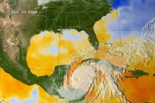
 10月19日,位於尤卡坦半島東南方海域、接近創紀錄最高強度的颶風威爾瑪 | |
| 形成 | 2005年10月15日 |
|---|---|
| 消散 | 2005年10月27日 |
(2005年10月26日起轉變成溫帶氣旋) | |
| 最高風速 | 1分鐘持續: 185英里/小時(295公里/小時) |
| 最低氣壓 | 882毫巴(百帕);26.05英寸汞柱 (在大西洋颶風創歷史新低) |
| 死亡 | 共87人 |
| 損失 | $294億(2005年美元) |
| 影響地區 | 伊斯帕尼奧拉島、牙買加、古巴、開曼群島、洪都拉斯、伯利茲、墨西哥東南部、美國東岸(特別是佛羅里達州南部)、巴哈馬、加拿大大西洋省份 |
2005年大西洋颶風季的一部分 | |
飓风威尔玛是2005年大西洋飓风季第二十一个熱帶风暴,同时又是第十二个飓风,同时平了這两个纪录。(但後來修定為十三个飓风)飓风威尔玛也是此飓风季中第三个五级飓风(后來艾米莉飓风短暫升級為五级颶風,所以威尔瑪飓风是當年第四个五级飓风),这打破了1960年大西洋飓风季和1961年大西洋飓风季以及1988年颶風吉爾伯特最低氣壓888百帕纪录。飓风威尔玛同时又是大西洋上有记录以来最强的熱帶氣旋,在全世界熱帶氣旋历史中是氣壓第十低的,其他的八个都是台风。飓风威尔玛对加勒比海西部包括古巴,中美洲造成严重威胁,墨西哥的尤卡坦半岛以及美国的佛罗里达州也遭受影响。
 播放媒体
播放媒体颶風威爾瑪全程雲圖動畫
目录
1 气象历史
2 参见
3 参考文献
4 外部链接
气象历史

根據薩菲爾-辛普森颶風等級的強度繪製的風暴路徑圖
| 最强烈的大西洋飓风 | |||||
|---|---|---|---|---|---|
| 排名 | 飓风 | 飓风季 | 气压 | ||
百帕 | 英寸汞柱 | ||||
| 1 | 威尔玛 | 2005 | 882 | 26.05 | |
| 2 | 吉爾伯特 | 1988 | 888 | 26.23 | |
| 3 | “劳动节” | 1935 | 892 | 26.34 | |
| 4 | 丽塔 | 2005 | 895 | 26.43 | |
| 5 | 艾倫 | 1980 | 899 | 26.55 | |
| 6 | 卡米尔 | 1969 | 900 | 26.58 | |
| 7 | 卡特里娜 | 2005 | 902 | 26.64 | |
| 8 | 米奇 | 1998 | 905 | 26.73 | |
迪安 | 2007 | ||||
| 10 | 瑪麗亞 | 2017 | 908 | 26.81 | |
| 来源:大西洋飓风数据库[1] | |||||
参见
- 2005年大西洋飓风季时间表
- 2005年飓风卡特里娜
参考文献
^ National Hurricane Center; Hurricane Research Division. Atlantic hurricane best track (HURDAT version 2). United States National Oceanic and Atmospheric Administration. 2014-03-24 [2014-03-28]. (原始内容存档于2014-03-28).
外部链接
维基新闻相关報導:
Hurricane Wilma becomes stronger on its path toward Florida
维基新闻相关報導:
Tropical Storm Wilma forms, ties record for busiest hurricane season
Tropical Cyclone Report on Hurricane Wilma.
afterwilma.info The Story of Cancún & the Riviera Maya's recovery including updates for travelers- Wilma in Cancun pictures & weBlog
- Wilma pictures, satellites images
- The Disaster Center's Coverage of Hurricane Wilma
Tropical Cyclones page - University of Wisconsin CIMSS
The Tropical Guidance page of Jonathan Vigh (PhD candidate at Colorado State in atmospheric sci) - many good spaghetti plots
Kerry Emmanuel's track page at MIT -- includes a legend of the model names
Extensive collection of imagery, media streams, etc., from Weather Nation- Hurricane tracking and forecasts for Hurricane Wilma
- Steve Gregory's blog at Weather Underground
- Jeff Masters' blog at Weather Underground
- Webcamplaza.net
- SkeetoBite Weather
Hurricane Local Statements from the U.S. National Weather Service gives evacuation orders, watches, warnings for affected areas of the United States as well as weather information- Tropical Storm Risk.com - Information on hurricanes and cyclones worldwide with maps and forecasts
GoogleEarthHacks.com Satellite images, forecasted storm track, webcams and more in a .KMZ-file for Google Earth! This file covers hurricanes worldwide, but is very useful for Wilma right now.- Numerous tracking graphics put together on one page, maintained for Wilma; NEW pictures and videos from Central Florida
Hurricane Digital Memory Bank Preserving the Stories of Katrina, Rita, and Wilma. Share your stories and images, or other types of digital files.
| |||||||||||||||||||||||
| ||||||||||||||||||||||||||||||||||
| ||||||||||||||||||||||||||||||||||||||||||
2005年大西洋颶風季的熱帶氣旋
|
| |||||||||||||||||||||||||||||||||||||||||||||||||||||